The Met Office has confirmed the chance of snow in Huddersfield is steadily on the rise.
Their yellow warning of ‘heavy snow’ for Sunday has been extended to include all of Kirklees and Calderdale .
And they have said we can expect snow over the next three days - with the first flurries expected this evening.
So this is your hourly guide from The Weather Channel of the weather to expect over the next few days and weekend.
Thursday
4pm - Partly cloudy
5pm - Few showers
6pm - Showers
7pm - 11pm Rain / Snow showers
Friday
6am - Mostly cloudy
7am - Partly cloudy
8am - Mostly clear
9am - 3pm Sunny
4pm - midnight Clear
Saturday
Mostly sunny
Sunday
Snow - 90 per cent chance of snow with between seven and 12cm expected to fall
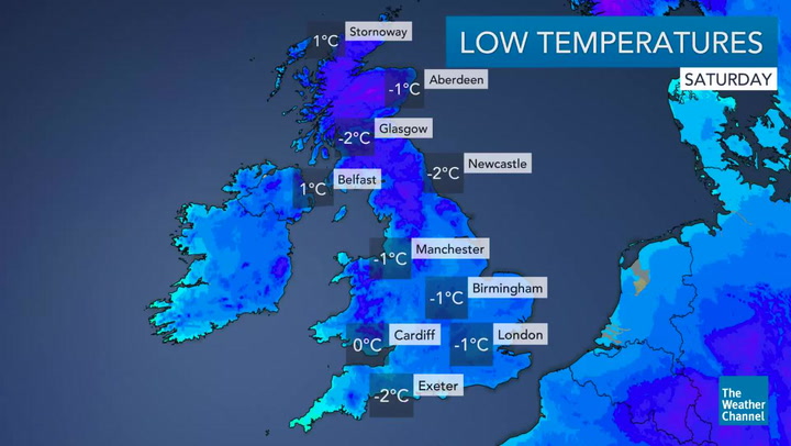
A spokesperson for The Weather Channel said: “Gale force and gusty winds along with heavy rain will spread south-east followed by frequent snow showers and blizzards over Scotland.
“A cold Arctic flow will develop and temperatures will drop sharply below normal with overnight frosts, crisp winter sun and snow showers over the weekend before more snow moves in during Sunday.”