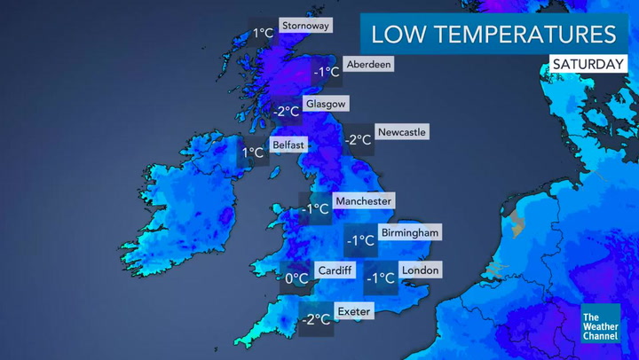
The chance of snow settling in Huddersfield over the weekend has gone up, the Met Office has announced this morning (Thursday).
A warning of ‘heavy snow’ on Sunday has been extended to include all of Kirklees and Calderdale.
The Met Office has issued a ‘Yellow’ warning – its least severe category – for snow for all three days.
Forecasts for Friday and Saturday have Huddersfield on the fringe of a potential area of snow.
But weather experts have cautiously predicted at least 1cm of the white stuff falling across most of northern England and the Midlands at some point on Sunday.
Its chief forecaster says: “A band of rain, heavy at times, is expected to move eastwards over the UK.
“With cold air in place, a spell of snow looks likely to develop on its northern edge.
“One to five centimetres is possible quite widely, and up to 10 cm in places.
“Over higher ground, 20 cm is possible in a few places.
“There is currently a good deal of uncertainty over the precise track of the areas of rain and snow.”
Huddersfield meteorologist, Paul Stevens, said it was still too early to be certain how significant the snow fall would be.
The Salendine Nook based weather forecaster said: “Tonight it will turn colder and there may be some sleety showers up towards Buckstones or Holme Moss.
“But if you think you’re going to wake up to ‘deep and crisp and even’ you’re going to be disappointed.
“Friday is a sunny day with scattered snow showers, mostly to the south west of Kirklees towards the Greater Manchester or Lancashire borders.
“It will be a bitterly cold night with a sharp frost overnight with temperatures plummeting to -2 or -3 celsius.
“Saturday is looking like a nice day although there could be icy patches in areas where there’s been water run off.
“Sunday is still uncertain but it looks like there could be snow of about 1cm to 5cm in the morning.
“The heaviest of it is still forecast to come from the west of Kirklees and down towards the Midlands.”